_edited.jpg)
2017-2018
Over fifty flyovers were documented as part of a project that investigates the spaces created by transport infrastructure. The hundreds of flyovers built over a short time in Indian cities is unusual - they dominate the urban landscape and their giganticism was exploited to physically emulate that of the global world-class city.
This simulation may be convincing to those on the highway or in aerial shots that market the city, but a camera at ground-level uncover pluralistic environments underneath and reveal more of the true nature of the city as experienced as local everyday neighbourhoods.
_edited.jpg)
.jpg)
.jpg)
In urban India, motorways were built not only to facilitate national mobility and global connectivity to trade networks, but the flyover’s incredible scale and grandeur was particularly appropriated as a representation of the modern - completed flyovers were celebrated in the media as an exciting sign of progress in the vein of the megaprojects in desirable world cities such as Dubai and Shanghai and its success judged in terms of its image. A massive boom in construction resulted in hundreds of flyovers now ubiquitous in the urban fabric, forming a dominating characteristic of the Indian city.
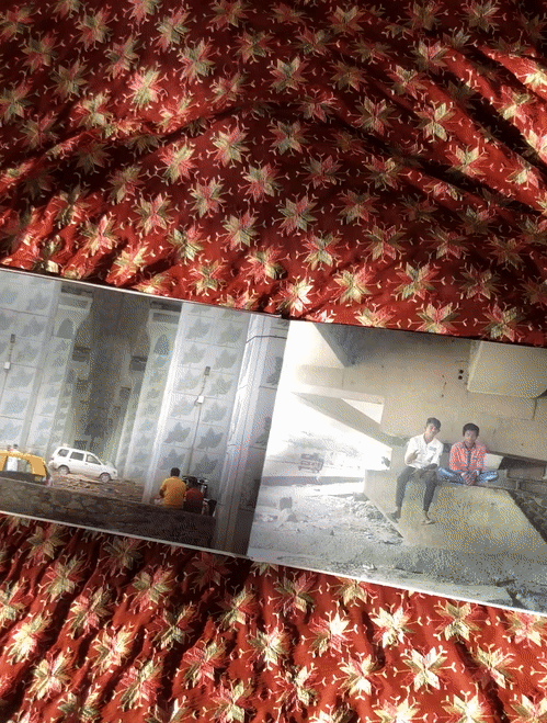
In reality, the space beneath the flyover acts as a threshold between infrastructure and street, and is inhabitable. It is a vehicle for an intricate set of uses, with the form of its concrete supports and highway cover drastically transforming temperature, acoustics, levels of light and thereby generating unique and dynamic spatial conditions in the city. These variable environments created by the flyover stand in contrast with the more singular and top-down ways in which the flyover is conceived in its planning stages - here, maps remain a primary method of analysing and planning a city, but tend to obscure the stratifying effects of building tall or covering over.
In many ways, the flyover has exacerbated socio-economic disparity in the city as an instrument of capital that benefits the business bourgeoisie and does not trickle down to a vast majority of the population. In doing so, the spaces it creates has also privileged elite groups of car-owners and very physically created an underclass below – meanwhile all looks well from aerial views of the world-class city.
.jpg)
_edited.jpg)
_edited.jpg)
.jpg)
.jpg)
.jpg)
Flyovers may be deemed a private infrastructure, benefiting only the few who have access to it, yet it is clear that they are fertile ground that can be claimed and re-appropriated. Its commercially attractive global aesthetic is at great odds with the life we find beneath it - moving through the city on foot, we see how the flyover is consumed not only as a defining everyday backdrop to the city, but also as shelter, storage, green space and furniture. It's not difficult to imagine how, with more care, these flyovers may be transformed into more inclusive spaces in the city. It is these leftover spaces that evades the eye of the city-planner and mapper, where urban neighbourhoods are organically created and form popular perceptions of the Indian city.
These photographs investigate the socio-spatiality of the flyover, as a camera at ground-level speaks more of the poetics of transport infrastructure. That is, its sensory and material qualities – how it feels, sounds, and smells to a local population. It speaks of how spaces created by transport are still left open for interpretation. Each flyover documented showcases distinct characteristics that attest to the influence people have to play in creating spaces for their own in the city
.jpg)
.jpg)
.jpg)
.jpg)
.jpg)
.jpg)
.jpg)
.jpg)
.jpg)
.jpg)
.jpg)